
Science Writing

The Daily Packard: An inside look at life aboard the David Packard
Life at sea aboard R/V David Packard has been both challenging and rewarding. The weather hasn’t always cooperated—winds pushed us away from our original dive site early on—but the relocation opened the door to new mapping opportunities and unexpected discoveries.

Towering corals and tiny worms: Mapping the invertebrate community on the deep seafloor
What does a complete deep-sea ecosystem actually look like? What shapes the patterns of life we find there? How do these patterns change over time? These are the kinds of questions that have long been difficult to answer—until now.

Small but mighty: Surveys at Sur Ridge prove the power of a portable ROV
After several days of strong winds and heavy swell, the ocean finally settled enough on Sunday and Monday for the MiniROV team to return to our original dive site at Sur Ridge. We deployed the vehicle at a striking rock formation on the northern side of Sur Ridge, approximately 1,230 meters (4,035 feet) below the surface.

A match made in the deep: Science, engineering, and marine operations
From coding the software that controls underwater robots to counting the bristles and teeth on tiny worms, the work of engineers and scientists may seem worlds apart. Yet in the deep sea, these disciplines come together with a shared purpose: to explore, understand, and help protect our ocean.

MBARI's advanced technology transforms the monitoring of aquatic ecosystems
Partnerships across the country and overseas bring the power of MBARI’s Environmental Sample Processor to ecosystem health assessments in the ocean and our nation’s waterways.

Elevating marine research: MBARI’s aerial drones provide fresh insights into ocean life
Uncrewed aerial vehicles outfitted with high-resolution cameras and advanced sensors give MBARI researchers a new perspective on marine life and phenomena.

MBARI shares latest tech innovations for visualizing ocean life and ecosystems at Marine Imaging Workshop
As co-host of the Fifth Marine Imaging Workshop, MBARI brought together experts in ocean visualization from around the world.

The Future of Hurricane Forecasting: Hurricane Analysis and Forecast System
AOML’s Hurricane Modeling Group was founded in 2007 to advance hurricane forecast models through development and targeted research.

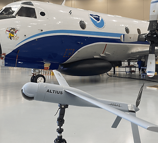
NOAA Deploys New Black Swift Drone into Tropical Storm Tammy
NOAA hurricane researchers successfully deployed a new uncrewed aircraft system (UAS) into Tropical Storm Tammy (2023) to measure parts of the storm too dangerous for humans to go.
NOAA Measures Hurricane Tammy from Satellites through the Sea
Uncrewed aerial vehicles outfitted with high-resolution cameras and advanced sensors give MBARI researchers a new perspective on marine life and phenomena.

NOAA’s Multi-Faceted Hurricane Data Collection Efforts Provide a Detailed View of Hurricanes Franklin and Idalia
As Hurricanes Franklin and Idalia strengthened in late August, NOAA scientists collected critical data from the air, sea surface, and underwater to enhance forecasts and increase scientific knowledge.

12 Days of AOML Research
From responding to heat waves to setting records and launching new tech, our dedicated team continues to push the boundary in an effort to support NOAA’s mission to build a climate-ready nation.